Historically, most major floods in Albany have occurred December, January, and February, although flooding in other months is possible. Heavy rains that saturate the ground and fill rivers and creeks coupled with warming weather that melts heavy mountain snow created the major flooding that Albany has seen over the last 150 years.
The last major floods since the dams were built on rivers upstream took place in 1964 and 1996. The February 1996 flood was the highest in recent memory but was considered significantly less than a "100-year flood," which is a flood that has a 1 in 100 (1%) chance of happening in any given year. The Christmas Flood of 1964 caused $157 million in damage, and 20 Oregonians lost their lives.
County records dating back to the mid-1800s indicate that the Willamette River has caused significant flooding to the County at least seven times. The record flood of 1861 had almost three times the volume of water in the Willamette River as measured at the Albany gauge. The 1964 flood would have rivaled the 1861 flood without the flood controlled dams.
If you are in the floodplain, odds are that someday your property will be damaged. Even if you don't live in a floodplain, knowing what to do (and not to do) in a flood can be life-saving.
High Water Mark of Past Floods
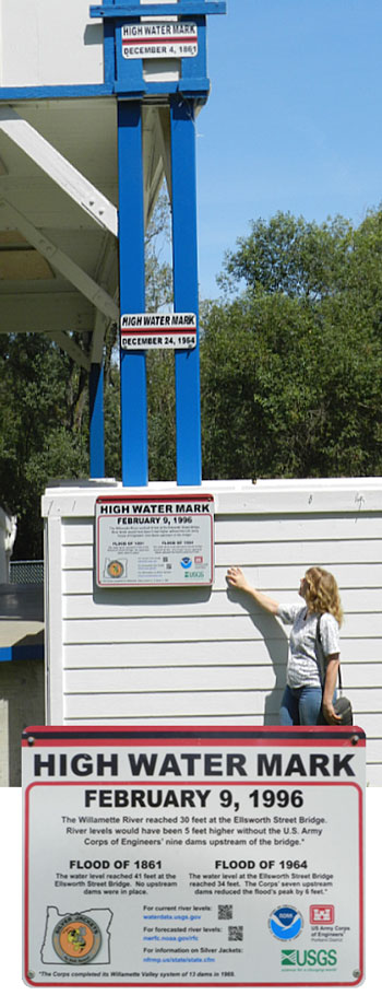
To illustrate the difference in flood heights and to promote awareness of flood hazards, the City of Albany and the U.S. Army Corps of Engineers installed high-water mark signs at Monteith Riverpark in December of 2014. The timing of the installation was significant as it commemorated 50 years from the date of the 1964 Christmas Eve flood event. The signs are posted at the level flood waters reached Ellsworth Street on December 4, 1861; December 24, 1964; and February 9, 1996. The signs also list the number of upstream dams in place at the time of the latter two floods and how much those dams reduced flood levels.
Since the floods of 1861 and 1964, a variety of mitigation efforts have helped to reduce the impact of floods, such as the dams at Foster and Green Peter. For example, without the dams:
In 1996, the Willamette River reached 30 feet at the Ellsworth Street Bridge. River levels would have been five feet higher without the U.S. Army Corps of Engineers’ nine dams upstream of the bridge.
In 1964, the water level at the Ellsworth Street Bridge reached 34 feet. The Corps’ seven upstream dams reduced the flood’s peak by six feet.
In 1861, the water level reached 41 feet at the Ellsworth Street Bridge. No upstream dams were in place at that time.
USEFUL LINKS
- Past flood photos
- 1964 Christmas Flood
- Christmas Flood website (Army Corps of Engineers)


